Bjni is a village of about 2,500 people in Kotayk province, 43 km by road north-east of Yerevan on the right bank of the Hrazdan river, where the gorge opens out below Charentsavan. It was the family seat of the Pahlavunis, the 11th-century princes who gave Armenia the scholar Grigor Magistros and a catholicos, and the 1031 church he founded still stands under a cliff-top fortress whose walls have been dug and partly rebuilt. The name is better known from a bottle: Bjni mineral water has been on Armenian tables since the 1970s, and most people who drink it have never seen the place. You can see all of it in a half-day from Yerevan or Tsaghkadzor.
Bjni and the Pahlavunis
The village is old. The 5th–6th-century historian Ghazar Parpetsi mentions it, which puts it on the map before any surviving building. Its real moment came under the Bagratuni kings, when Bjni and the surrounding district belonged to the Pahlavuni family. Vasak Pahlavuni, lord of the fortress, was the father of Grigor Magistros (c. 990–1058), who was born here and whose 88 surviving letters, written between about 1030 and 1059, are one of the main windows into the late Bagratuni court (Byzantine and Modern Greek Studies). His uncle Vahram Pahlavuni was the kingdom’s sparapet, its commander-in-chief.
In 1031, by order of King Hovhannes-Smbat and Catholicos Petros Getadardz, Grigor built the church of Surb Astvatsatsin and Bjni became an episcopal seat (AUA Armenia Hidden Gems). Within fifteen years the Bagratuni kingdom was gone: in 1045 Grigor travelled to Constantinople with the last king, Gagik II, and surrendered his ancestral holdings, Bjni included, to Byzantium in return for the court title magistros and estates in Mesopotamia, where he became governor in 1048. His son Vahram went into the church and was consecrated Catholicos Grigor II Vkayaser in the mid-1060s; one tradition places that election at Bjni itself. For the wider context, see our short history of Armenia.
What followed is the usual sequence. The Seljuks took the district; the Zakarian princes Ivane and Zakare retook it around 1200 and Prince Vahan renovated the monastery in 1209; a chapel was added in 1272; Timur’s army wrecked the village in 1387–88. The fortress fell out of use in the 16th–17th centuries. Bjni manuscripts dated from the 12th to the 17th century survive in the Matenadaran, which tells you the scriptorium kept working long after the princes left.
The fortress on the rock
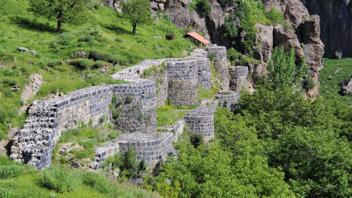
The fortress sits on a flat-topped mesa at about 1,500 m directly above the village, with the Hrazdan gorge on one side. For decades it was dated to the Pahlavunis, 10th–11th century. Excavations changed that. A survey in 1929 was followed by Yerevan State University digs in 1977–1988 (the first seasons led by Garibyan) and again in 2003–2004, which found a church of Surb Khach (Holy Cross) of the 9th–10th century under the later layers, plus a palace building, grain stores, a cistern and a covered passage running down to the river (AUA; Armland). So the Pahlavunis rebuilt an existing stronghold and, under Vasak and Grigor, doubled the walls. Finds included glazed and plain pottery, glass, metal and stone weapons and jewellery. In 2007–2008 the walls, the foundations of the secular building and the churches were consolidated and partly rebuilt.
What you see today: a stretch of curtain wall roughly 120 m long with semicircular towers, the outline of the Surb Khach church, the cistern, the mouth of the secret passage, and the palace footprint, rebuilt in noticeably clean, multicoloured stone. It is a fortified plateau with the bones of a small town on it, not a castle in the Western sense.
The climb: a narrow dirt track leaves the village and switchbacks up the side of the mesa. On foot it is about 15 minutes from the last houses and the surface is rocky and uneven. The government promised in 2022 to rebuild the access road because of its steep grade (Armenpress); whether that has happened, confirm locally before driving up in a low car. There is no ticket and no fence. The best views are from the northern and western edges, straight down into the Hrazdan gorge and across to the Tsaghkunyats ridge. Nothing is railed.
Surb Astvatsatsin (1031)
The church is in the middle of the village, west of the mesa, on the right bank of the river. It is a domed hall, 22.1 by 13.4 m, built of red and brown hewn tuff, with a pair of triangular niches on the east facade and a round drum carrying an umbrella-ribbed cone (AUA). It is small for an episcopal church; Bjni was a family seat, not a cathedral town.
The 1272 vaulted chapel is attached to the south side, with a large khachkar set into a niche in its west wall. The yard holds a group of khachkars, several signed by a Master Melikset, and more stand east of the church. It is a good place to compare 13th-century lace-work khachkars with plainer earlier stones in one enclosure.
Condition is the honest caveat. The walls were partly restored in 1939 and fully in 1956–57, but in July 2022 the prime minister told cabinet that a wall of the main church was in critical state and shored up with props, that a repair design existed and only funding was missing (Armenpress). We could not confirm whether the capital repair has since been completed, so expect scaffolding or a closed side and ask in the village. The church is in use by the Kotayk diocese; there is no fixed opening time we could verify, and in practice it is open when the caretaker is there.
Surb Sargis and the other churches
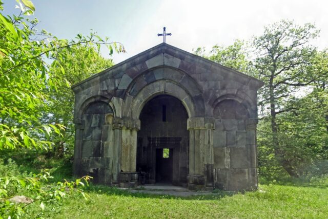
Surb Sargis is the oldest standing building: a 7th-century small cruciform church with a central dome, of the type that was spread across Armenia in that century (Armland). It stands on a rock outcrop at the eastern end of the village, next to the modern cemetery and east of the fortress, with carved inscriptions and animal reliefs on the exterior. It is a five-minute scramble from the cemetery gate and the best photograph in Bjni.
Surb Gevorg is a small church with khachkars built into its walls. The date is disputed between sources we read: English-language references give the 13th century, the Armenian-language ones the 8th. Treat it as medieval.
The mineral water
The Bjni–Arzakan deposit lies on both banks of the Hrazdan. The water is a cold (14–15 °C) chloride-bicarbonate, sodium-calcium type with 4–6 g of dissolved minerals per litre (geology.am). Armenian sources date the modern discovery of the springs to 1967 and the first bottling plant to 1976–77. The factory was never in the village; it is in Charentsavan, 10 minutes down the road.
After privatisation in 1995 the plant belonged to SIL Concern, the holding of businessman Khachatur Sukiasyan. In 2008, after he backed the opposition candidate in that year’s presidential election, tax authorities fined the company 5.2 billion drams, production stopped in the autumn, and more than 400 jobs went with it. A February 2009 auction was annulled by the Administrative Court; the plant was finally sold in bankruptcy in December 2009 for 4.3 billion drams to a buyer the administrator called a commercial secret (RFE/RL Armenian Service). It reopened in 2010 as the RRR Mineral Waters Plant, which bottles Bjni Classic, Elitar and Luxe and the Noy spring-water line. Whether the original spring in the village can be visited we could not establish; the geology museum lists it as a deposit, not a tourist site. The broader story of Armenia’s bottled springs is in our mineral-water towns guide,.
Getting there
| From | Road distance | Time | How |
|---|---|---|---|
| Yerevan | 43 km | 40–45 min | M4 north to Charentsavan, then 8 km east on the local road |
| Tsaghkadzor | 21 km | 25–30 min | via Hrazdan, then south-west |
| Hrazdan | 13 km | 15–20 min | local road along the river |
By car is the straightforward answer. Take the M4 (Yerevan–Sevan highway), leave at the Charentsavan exit and follow signs for Bjni; the last stretch drops into the gorge.
Marshrutka reality. There is no direct Yerevan–Bjni service that we could verify. Minibuses run to Charentsavan and Hrazdan from Yerevan (aggregators list a route 253 and departures roughly every 30 minutes; the departure point is given variously, so check on the day), and from Charentsavan you take a taxi for the last 8 km. Budget 1 h 15 min plus waiting. Read how to get around Armenia for the general rules.
Taxi from Yerevan via an app runs about 6,000–8,000 AMD each way at 2026 rates; arrange the return, because there is no rank in Bjni.
A half-day plan
- 09:00 leave Yerevan; 09:45 park in the village centre by Surb Astvatsatsin. 30 minutes for the church, chapel and khachkar yard.
- 10:20 walk or drive up the fortress track. One hour on top is enough for the walls, Surb Khach, the cistern and the gorge viewpoints.
- 11:30 drive to the eastern end of the village; Surb Sargis on its rock, 20 minutes.
- 12:00 onward. The honest pairing is Tsaghkadzor, 25 minutes away, for Kecharis monastery and lunch, or the ropeway in season. Garni and Geghard are on the far side of Yerevan and do not combine well.
It is a thinner day than our other day trips from Yerevan, which is why pairing matters.
When to go
May–June and September–October. The fortress track is mud in March and April and ice from December; the mesa is exposed and July afternoons are hot with no shade. Local hiking operators list the 13 km Tsaghkadzor–Bjni trail across the Tsaghkunyats ridge (about 400 m of gain, moderate) as best in May–June and October–November.
Practical notes
- No entry fees anywhere in the village. A small donation box at Surb Astvatsatsin.
- No cafes to speak of; one or two shops. Eat in Charentsavan, Hrazdan or Tsaghkadzor.
- Footwear: the fortress path and the Surb Sargis rock need proper soles.
- Last verified: October 2026.
Worth it?
Yes, with expectations set. Bjni is not Geghard or Noravank, and it will not appear in best-monasteries lists. What it offers is a complete 11th-century seat in one small valley: the family church, the fortress that paid for it, the 7th-century chapel that predates both, and a view down the gorge the Pahlavunis chose on purpose. Two hours, few visitors, no fee. If you are driving to Tsaghkadzor or Sevan anyway, skip it and you have made the mistake.
Frequently asked questions
How far is Bjni from Yerevan and how long does it take?
About 43 km by road via the M4 and Charentsavan, roughly 40 to 45 minutes by car or taxi. By public transport take a marshrutka to Charentsavan and a taxi for the last 8 km; allow 1 hour 15 minutes plus waiting.
Can you climb up to Bjni fortress?
Yes. A narrow dirt track leads up the mesa from the village; the walk is about 15 minutes on uneven ground. There is no entrance fee, no fence and no railing at the cliff edge, so take care with children and in wet or icy weather.
Is the Bjni mineral water spring in the village?
The Bjni-Arzakan springs are in the Hrazdan gorge around the village, but the bottling plant has always been in Charentsavan, 8 km away. We could not confirm that the spring itself is set up for visitors; ask locally.
Who was Grigor Magistros?
An 11th-century Pahlavuni prince born in Bjni (c. 990-1058), scholar and letter-writer, who built the 1031 Surb Astvatsatsin church. In 1045 he ceded Bjni to Byzantium for the title magistros; his son became Catholicos Grigor II.
Featured image: Beko, CC BY-SA 4.0 — via Wikimedia Commons.