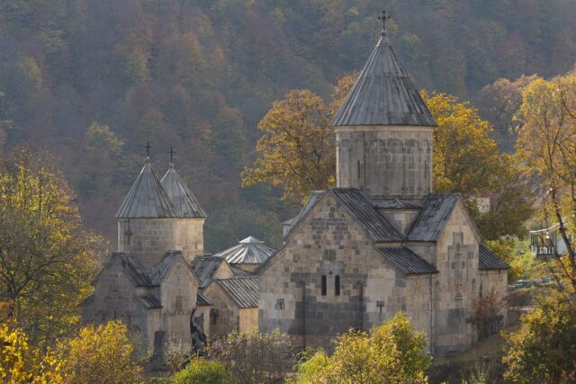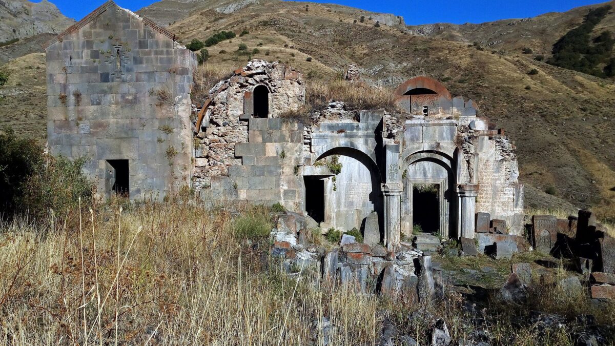
Arates Monastery (Արատեսի վանք) is a ruined 7th–13th-century monastic complex on a hill above the abandoned village of Arates, at the top of a side valley of the Yeghegis river in Vayots Dzor. Two churches, a 1270 gavit with an unusual intersecting-arch roof, a cluster of small chapels and khachkars dated from the 900s to 1713 sit at roughly 1,990 m, with nobody living nearby and no ticket booth. The medieval historian Stepanos Orbelian handed it to Noravank as a summer residence for the bishops of Syunik, which tells you most of what you need to know about the climate. It is also the start point of a 14 km walk down to Yeghegis, and that combination of ruin plus hike is the reason to come.
History: from the 7th-century tombs to the Orbelians
Armenia’s Service for the Protection of Historical Environment (hushardzan.am) dates the oldest church, Surb Sion, to the 7th century, Surb Astvatsatsin to the 10th and a third church, Surb Karapet, to the 13th. Other descriptions, including Armenian-language encyclopaedia entries and tour-company pages, push Surb Sion to the 10th century and Astvatsatsin to the 11th, treating the 7th century only as the site’s founding. The honest answer is that the dating is unsettled. A 2015–2020 survey by the University of Florence (Luschi and Vezzi, published 2025 by the Armenian Academy of Sciences) argues from the foundation platform and wall techniques that the earliest hall of Surb Sion belongs to the 4th–7th-century “formative” period, and found three distinct masonry techniques, meaning at least three building campaigns.
The dated material is firmer. The oldest inscription at the site is from 907. In 1073 a man named Artavazd gave the monastery a vineyard and estates at Yeghegis. In 1220 Prince Vasak Khaghbakian recorded on a monastery wall the recovery of the Vayots Dzor fortresses. Then came the Orbelians. The gavit was added in 1270 under abbot Hayrapet, and at the end of the century Stepanos Orbelian, metropolitan of Syunik and author of the History of the Province of Syunik, folded Arates into Noravank’s estates. His own donation charter, preserved in his History (Brosset’s 1864 French edition is online), says it plainly: because the extreme heat made Noravank uninhabitable for the bishops in summer, he fixed on the convent of Arates “above Yeghegis” and gave it, with its village and boundaries, to Noravank in perpetuity. In 1301 he added eight villages in Gegharkunik, and in 1303 a scribe copied a commentary by Gregory of Nyssa here: Arates was a working scriptorium, not a hermitage. The enclosure wall was destroyed in the 17th century, the latest dated stone is 1713, and the village itself was empty by the 2011 census.
What’s on site
The buildings line up north to south on three terraces, and the monuments service counts nine structures: four large and five small. The names on the inscriptions do not map cleanly onto the buildings, which is why different sources attach “Surb Karapet” to different rooms.
Surb Sion
The northernmost and oldest building: a single-nave, barrel-vaulted hall with small chapels flanking the apse, standing on a stepped foundation platform that doubles as drainage. Look for the row of blind arches on the south wall: the back wall of a vanished side portico, a feature you will not see on many other Vayots Dzor churches.
The small gavit and Surb Astvatsatsin
Between the two churches is a square covered room with paired pilasters, the earlier of the two gavits. South of it stands Surb Astvatsatsin, a barrel-vaulted hall on paired piers, with reused carved blocks from the old portico built into its north face.
The 1270 gavit
This is the piece worth the drive. Built on the west side of the group by abbot Hayrapet, with the architect named in Armenian sources as Siranes, the master who also worked at Noravank. (Some accounts add that Prince Smbat Orbelian commissioned it around 1265–70; I could not confirm that from a primary source.) The roof is the point: instead of the usual four columns, it rested on two parallel pairs of arches running north–south, tied to the east and west walls by half-arches, with a carved stalactite-style central vault. The monuments service calls it the most interesting building in the complex. The central vault collapsed in the 1970s, so you are looking at arch springings and fallen voussoirs rather than a ceiling.
Khachkars, tombs and inscriptions
Khachkars and tombstones here span the 10th to the 17th centuries, and older guides single out five small 7th-century tombs. The 1220 Vasak Khaghbakian inscription and the 1073 Artavazd donation are both on the walls. Go in the morning when the light rakes across the east faces. For what these stones mean, see our guide to Armenian khachkars. Downstream there is an old stone bridge, and to the north the Florence team found what looks like a fortified structure and a boulder painted with a red-and-white cross marking the edge of the monastic lands.
The name legend
Every local telling derives Arates from ari, tes, “come, see”, the words with which someone summoned a visitor to the view. It is folk etymology, not history. Orbelian’s 13th-century text already spells it Arates, so the name is at least 700 years old whatever its origin.
Getting there
From Yerevan take the M2 south to Yeghegnadzor (about 120 km, 2 hours), then the Yeghegis valley road north through Shatin and Yeghegis village to Hermon. Beyond Hermon, take the left fork and then the next left, signposted for Arates Vank; the road climbs north-east up the side valley to the dead village and the monastery hill. From Yeghegnadzor to the monastery plan on 25–30 km and around an hour of driving. Tour operators quote 150 km from Yerevan.
- The Shatin–Hermon stretch is asphalt. Older guides describe the final Hermon–Arates road as asphalt too, but it is a mountain road that suffers from mudflows (Armenia’s rescue service has logged them at the 12 km mark of the Shatin–Hermon road), so expect broken surface and washouts. A normal car gets there in dry weather if you drive slowly; a high-clearance vehicle makes it comfortable. See our notes on renting and driving in Armenia.
- There is no public transport to Arates. Marshrutkas from Yeghegnadzor serve Shatin and Yeghegis; from Hermon you walk or hitch the last stretch.
- A taxi from Yeghegnadzor with waiting time is the practical option if you are not driving. Agree the price first.
The Arates–Yeghegis hike
The classic way to do Arates is one-way: get dropped at the monastery and walk out. The route runs about 14 km from Arates down forest tracks and mountain roads to Yeghegis village, and the tour operators who run it grade it medium. You start near 1,990 m at the monastery and finish in the Yeghegis valley, so the day is mostly descent with short climbs, 4–5 hours at a relaxed pace. A shorter alternative is Arates to Goghtanik waterfall and back, about 4 km in total, with a swim at the bottom if the water is up.
- Water: the Arates stream (the Martuni tributary of the Yeghegis) runs near the monastery, but treat or filter it. Carry 2 litres; the middle section is dry and exposed.
- Navigation: this is not a waymarked trail. Download a track beforehand (Wikiloc has one titled “Arates Monastery”) or go with a guide. Phone signal is patchy above Hermon.
- Wildlife: the Yeghegis valley has one of Armenia’s recovering bezoar goat populations; the Shatin observation point, set up in 2008 with Norwegian support, reports around 100 on the cliffs near the hide, and dawn sightings on the Arates slopes are common. Brown bears live in these forests too; make noise in thick sections.
If you want the bigger picture of walking in this valley, the best hikes in Armenia post puts the Yeghegis routes in context.
Access and the checkpoint question
The honest caveat: the most widely copied English description of the approach (armeniapedia, drawing on a 2000s-era guidebook text) says the asphalt road from Hermon “winds to a small military checkpoint, beyond which is the village of Arates”. Arates sits on the ridge between Vayots Dzor and Gegharkunik, not on an international border, and none of the recent Google or Tripadvisor reviews (37 on Google, some from 2025) mention being stopped. The Florence team worked on site every year from 2015 to 2020 without reporting access problems. So the checkpoint, if it still exists, appears to be a formality; but I could not verify its current status from a primary source. Carry your passport, do not photograph soldiers or installations, and ask before you set out: the Yeghegnadzor tourism information centre or any guesthouse host in Yeghegis or Hermon will know whether the road is open that week.
When to go
Late May to mid-October. Orbelian chose Arates because it is cool when Noravank bakes, which also means snow for much of the winter and a road that closes early. June brings wildflowers and a full Goghtanik waterfall; September and early October are clearest for photographs and goats. In July and August start the hike at dawn; the middle section has no shade.
Practical notes
| Item | Detail |
|---|---|
| Entry | Free, unfenced, no opening hours |
| Elevation | About 1,990 m at the monastery |
| From Yeghegnadzor | 25–30 km, about 1 hour by car |
| From Yerevan | About 150 km, 3 hours |
| Facilities | None. Nearest shop and guesthouses in Yeghegis and Shatin |
| Time on site | 45–90 minutes for the ruins; a full day with the hike |
| Coordinates | 39.9048 N, 45.4397 E |
Wear boots: the terraces are rubble and the gavit floor is fallen stone. Do not climb the arch stubs.
Pair it with
- Yeghegis village on the way in: the 13th-century Jewish cemetery, Zorats church with its open-air altar, and three other medieval churches within a few hundred metres.
- Smbataberd and Tsakhats Kar: an 11.9 km loop from Yeghegis with 600 m of climbing. With Arates, the best two-day walking combination in Vayots Dzor.
- Noravank: the mother house after the summer house; Siranes’ gavit there is the finished version of the ruin at Arates. See our Noravank guide.
- Selim caravanserai: the 1332 Orbelian caravanserai on the Vardenyats pass, 30 minutes further up the valley road.
Worth it?
Yes, for the right person. If you want a monastery with a roof, frescoes and a café, go to Noravank and skip this. If you want to stand in a 1270 gavit that only a few hundred visitors a year reach, read a 1073 land grant on the wall, and then walk 14 km down an empty valley with a chance of bezoar goats, Arates is the best half-known site in Vayots Dzor. Budget a full day, confirm the road locally, and go in the morning.
Last verified: October 2026.
Frequently asked questions
Do I need a 4×4 to reach Arates Monastery?
Not in dry weather. The road from Shatin through Yeghegis to Hermon is asphalt, and the final climb to Arates is a broken mountain road with occasional washouts. A normal car driven slowly manages it; high clearance makes it easier, and after rain or in early spring ask locally before trying.
Is there really a military checkpoint on the road to Arates?
Older guides describe a small checkpoint beyond Hermon. Recent visitor reviews and the 2015–2020 Florence survey team report no access problems, so if it still operates it is a formality. Carry your passport and confirm the road is open with the Yeghegnadzor tourism office or a guesthouse in Yeghegis.
How long is the Arates to Yeghegis hike?
About 14 km one way on forest tracks and mountain roads, mostly downhill from roughly 1,990 m, and graded medium. Allow 4–5 hours and carry 2 litres of water. A shorter option is Arates to Goghtanik waterfall and back, about 4 km in total.
Why did Stepanos Orbelian give Arates to Noravank?
His own donation charter, preserved in his History of the Province of Syunik, says the summer heat made Noravank uninhabitable for the bishops, so he fixed on the monastery of Arates above Yeghegis as a summer residence and gave it to Noravank with its village and lands.
Featured image: Soghomon Matevosyan, CC BY-SA 4.0 — via Wikimedia Commons.