Koghb and Noyemberyan sit in the far north-eastern corner of Armenia, in Tavush, roughly 185–195 km from Yerevan by road and about 9 km short of the Georgian border. Koghb is the largest village in the province (4,420 people at the 2011 census; locals say around 5,000), with a 12th–13th-century monastery, Mshkavank, 3 km up a rough track, a village museum, and a cluster of Bronze Age and medieval fortresses on the surrounding ridges. Noyemberyan is the small Soviet-renamed town next door that most people only see from the Tbilisi highway. Both are 2–5 km from the Azerbaijani line, so this is a trip for travellers who read the border section below and still want to go.
Where this is and why almost no one goes
Noyemberyan is the northern tip of Tavush: 54 km north of Ijevan, 820 m above sea level, with the Azerbaijani border about 2 km to the east and Georgia about 9 km to the north. Koghb is 4 km from the town at 750 m, on the Koghb river, which is the valley that the medieval canton of Koghbapor was named after. The 7th-century Ashkharhatsuyts lists Koghbapor as the third canton of Gugark; the Armenian Wikipedia entry also cites Movses Khorenatsi for it, a claim I could not check against Thomson’s English translation, so treat the Khorenatsi link as reported, not confirmed.
Why nobody goes: Yerevan–Tbilisi traffic is heading for the Bagratashen crossing and has no reason to turn off, tourists in Tavush stop at Dilijan, and the border puts people off. The result is a large, culturally busy village with no visitor infrastructure and a monastery you will have to yourself.
Koghb — the village and the Salt Road (a mix-up worth clearing up)
First, the honest caveat, because English sources get this wrong constantly. There are two Koghbs. The Koghb famous for salt, the one on the medieval “Salt Road” and at the foot of Mount Bardogh, is in historical Chakatk canton of Ayrarat, and today it is the Turkish town of Tuzluca (“salt mine”) on the Araks. ArmGeo, the Armenian mountaineering outfit, describes Bardogh as a 2,562 m volcanic peak climbed from the Turkish side, and says plainly that the salt village at its foot is now Tuzluca. The Salt Road ran from that Koghb towards Alexandropol (Gyumri) and Georgia; ArmGeo reports 80,000-plus tons of rock salt moved along it in the 19th century before the 1902 railway killed it.
None of that is Tavush Koghb. No source I found, Armenian or English, describes salt here; the listed resources are iron, mercury, zeolite and forest produce. So: no Salt Road, no Bardogh hike. What Tavush Koghb does have is more interesting than a mis-copied fact.
The village is big: two secondary schools (founded 1928 and 1972), a music school (1993), a cultural centre running since 1945 with a puppet theatre, and the Koghb Charity Art School, founded in 1999 by the artist Karo Ghulijanyan, which teaches more than 100 children drawing, pottery and carpet weaving (reported by AUA’s Highlander magazine in 2022). The Koghb History Museum, founded in 1970, holds about 1,700 objects including ceramics the museum dates at 3,000–3,700 years old, pulled from the tomb fields around the village. Armenian Wikipedia credits Koghb with Armenia’s first rural hydroelectric station (1921). Emigration is described as comparatively low, unusual for a Tavush border village.
Museum and art school are in the village centre; hours are not published, so ask at the cultural centre. Russian or Armenian helps.
Mshkavank monastery
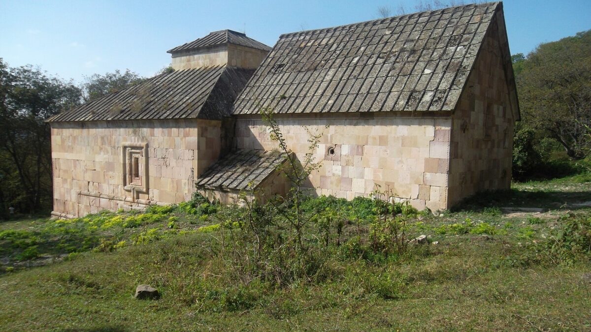
Mshkavank (also written Mshakavank) is the reason to come. It stands on a forested plateau about 3 km south-south-west of Koghb, at roughly 41°09′51″N 44°58′15″E. Armenian Wikipedia and ArmeniaDiscovery both date the complex to the 12th–13th centuries; the historian Vardan Areveltsi mentions it as already standing before the 1219 earthquake, and a scribe named Barsegh finished a scriptural commentary there in 1281, so it was a working scriptorium in the Zakarid period. The “5th-century St Astvatsatsin” in the English Wikipedia entry comes from the Kiesling–Kojian Rediscovering Armenia inventory; the Armenian sources give no foundation date and call the standing church 12th-century. I would not repeat the 5th-century date with confidence.
What you see: a single-nave, barrel-vaulted hall church with a semicircular apse and narrow two-storey chambers either side of it, round windows in the long walls, and a west-facing entrance under a semicircular arch. The gavit (narthex) in front is the architectural reason specialists bother with this place: its central square is roofed by pairs of intersecting arches without any central columns, a system the Armenian literature compares to Haghpat and Gandzasar, plus a western extension on paired cylindrical piers under a four-pitched roof. A ruined chapel-sacristy stands to the south and a 12th–16th-century cemetery of khachkars surrounds the church. The complex was consolidated in 1955–60 under architects H. Hakobyan and Yuri Tamanyan and is listed monument 10.41.23. It is not active.
The track from Koghb is unpaved and described in Armenian as hard going; a high-clearance car makes it, a normal rental does not after rain. On foot it is about an hour each way with 250–300 m of climb through oak forest, which is the better way anyway. For context against the bigger names, see our monasteries guide.
Fortresses and the ridge walks
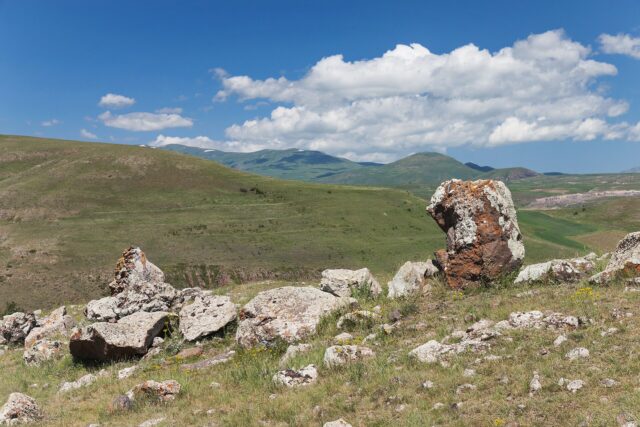
Koghb has 72 registered monuments, most of them Bronze Age to early medieval fortification sites on the ridges. The two inventories (Armenian Wikipedia and Kiesling–Kojian) agree on the main ones:
| Site | Distance from Koghb | What it is |
|---|---|---|
| Berdategh | 1.5 km south-east | Cyclopean (dry-stone megalithic) fort, 2nd–1st millennium BC |
| Gharanots Gol | close to Berdategh | Second cyclopean fort |
| Patrashar / Patashar | 6–15 km south-west (sources differ) | Cyclopean fort |
| Zikurati and Kozman | about 10 km west | Two cyclopean forts with Bronze Age tomb fields alongside |
| Kondokhavank | 13 km south-west | Fortress with a 12th–14th-century church |
| Berdavan (Ghalinjakar) | 2 km north of Noyemberyan, 1 km east of Berdavan village | Triangular-plan castle at 664 m on the Koghbajur river; 10th–11th-century origin, present walls mostly 17th-century, eleven linked towers |
Berdategh is the easy one: a short walk from the village edge to a ridge of collapsed cyclopean walls. Berdavan is the most impressive standing structure and is reached by car. The western forts are a full day with a local guide and are not waymarked; for marked trails you want Dilijan and Ijevan instead.
Noyemberyan — the town
Until 1937 this was Barana, a village whose name, by the local story, is a corruption of “from Aparan”, the answer settlers gave when asked where they came from. In 1938 it was renamed Noyemberyan, “November town”, for the Red Army’s entry into Armenia in November 1920. It became an urban-type settlement in 1971 and a town in 1995. Population peaked at 6,116 in 1989 and was 4,327 at the 2023 count.
What is there: a main square with a park, a small hotel on its west side and a larger one on the Koghb road, two churches, a market, and the dairy and canning plants that are the real economy, with peaches and grapes. Medieval traces are modest: a cyclopean fortress ruin on the northern edge of town (2nd millennium BC) and St Sargis church at nearby Dovegh. It is where you sleep and buy bread, not a day’s destination.
The border reality
Stated neutrally: Noyemberyan’s eastern villages (Baghanis, Voskepar, Koti, Berdavan) sit on the line with Azerbaijan’s Qazakh district, and the Ijevan–Noyemberyan highway runs within sight of Azerbaijani positions on the Kirants–Voskepar–Baghanis stretch. Armenpress and the Caucasian Knot reported recurring fire on Baghanis and Voskepar in 2019–2021, usually property damage, no casualties. Koghb, 5 km from the line, has not been hit in anything I found. The 2022 AUA essay describes taxi drivers speeding through the exposed sections out of habit.
Since April 2024 the situation has changed, not necessarily for the worse. Armenia and Azerbaijan agreed the first delimited sections of their border precisely here, between Baghanis–Baghanis Ayrum, Voskepar–Ashaghi Askipara, Kirants–Kheyrimli and Berkaber–Gizilhajili; Armenia handed back four abandoned villages and a short section of the old highway with a bridge at Kirants, and in July 2024 opened the rebuilt Kirants–Acharkut bypass (about 4 km longer). Border guards now stand where soldiers did. Incidents have dropped; they are not zero and the arrangement is new. Check before you go: your government’s travel advice, Armenpress or CivilNet, and the driver or host, who will know that morning. Do not photograph positions, guards or the line. Our safety guide has the broader picture.
Getting there
- From Yerevan by car: M4 via Sevan, Dilijan and Ijevan, then the M16 north through Kirants (on the new bypass), Voskepar and Baghanis to Noyemberyan. 185–195 km, allow 3.5 hours. See our driving guide for rental caveats; the Mshkavank track needs clearance.
- By marshrutka: minibuses to Noyemberyan leave from Yerevan’s Kilikia central bus station; schedules are not published online reliably, so go in the morning and ask. Noyemberyan–Koghb is a 4 km taxi or local bus.
- The Georgia angle: the M6 from Vanadzor–Alaverdi reaches the Bagratashen–Sadakhlo crossing, which is open 24 hours and is the main Yerevan–Tbilisi road crossing. Noyemberyan is about 15 km south of it and 91 km from Tbilisi. If you are doing the Yerevan–Tbilisi run on the eastern road, this is the one worthwhile stop; it fits a combined Armenia–Georgia itinerary as a half-day.
When to go
May–June and late September–October. Koghb is low (750 m) and the valley is hot and humid in July–August; the forest plateau at Mshkavank is cooler but the track turns to mud after rain. Autumn colour in the oak forest is genuinely good in the second half of October. Winter closes the track to anything but boots.
Where to stay and eat
Thin, and I have not stayed in any of them, so this is from listings only: a handful of Noyemberyan guesthouses on booking platforms (Berdavan Guesthouse in the next village reviews best; NoyemBurg, SAM and Toon 16 also list), the two town hotels, and one rental in Koghb. Food is square cafés or your host’s cooking; Tavush dairy is the strength. Alaverdi and Ijevan have more choice.
Practical notes
- Carry your passport: there are police and border-guard checks on the M16 and near Bagratashen.
- Cash. Card acceptance in Koghb is unreliable; Noyemberyan has ATMs.
- Fuel in Noyemberyan; patchy signal on the Mshkavank plateau.
- Last verified: October 2026.
Verdict
Go for Mshkavank’s gavit, Berdavan’s walls and a village that runs its own art school on the border, with your eyes open about where you are. Skip it if you want trail infrastructure, English-speaking hosts or certainty about the border; Berd and Dilijan give you Tavush with less exposure. And if anyone sells you a Koghb salt mine, ask which Koghb they mean.
Frequently asked questions
Is Koghb the village with the famous salt mines and the Salt Road?
No. The salt-mining Koghb on the medieval Salt Road, at the foot of Mount Bardogh, is in historical Chakatk canton and is today Tuzluca in Turkey. Tavush Koghb has no documented salt deposit; its draw is Mshkavank monastery, the fortresses and the village itself.
How old is Mshkavank?
Armenian sources date the standing church and gavit to the 12th–13th centuries; Vardan Areveltsi records it as existing before the 1219 earthquake and a manuscript was finished there in 1281. The 5th-century date found in some English inventories is not supported by the Armenian literature.
Is it safe to visit Noyemberyan and Koghb?
Noyemberyan’s eastern villages and the Ijevan–Noyemberyan road are on the Azerbaijani border and saw shelling in 2019–2021. Since the April 2024 delimitation of this exact section and the new Kirants bypass, incidents have fallen, but check current government advice and local news before travelling, and never photograph positions.
Can I get to Mshkavank with a normal car?
Usually not. The 3 km track from Koghb is unpaved and bad after rain; use a high-clearance vehicle or walk it in about an hour each way.
Featured image: Soghomon Matevosyan, CC BY-SA 4.0 — via Wikimedia Commons.