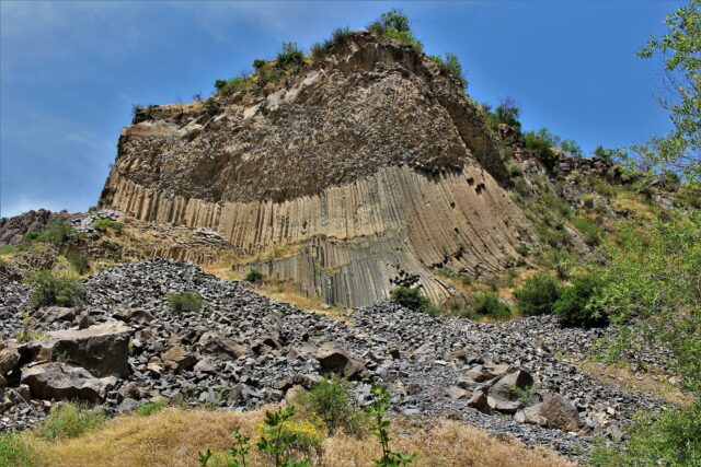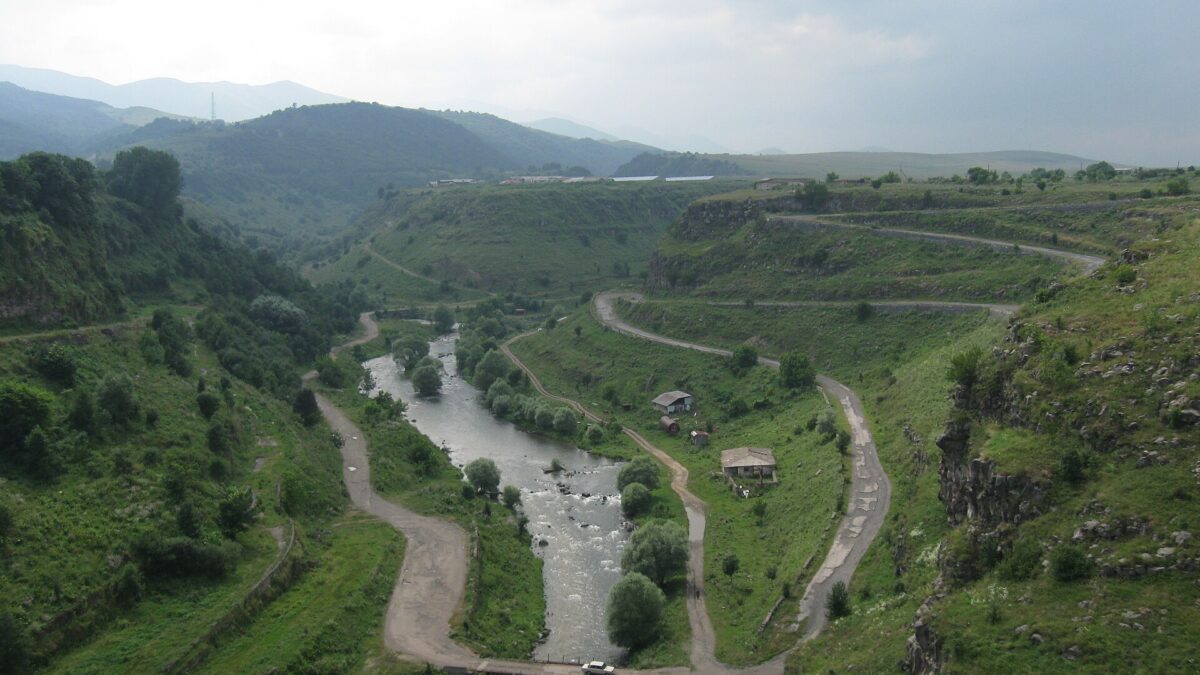
The Dzoraget is a 67-km river that cuts a basalt gorge 100–300 m deep straight through the middle of Stepanavan, Armenia’s old pine-forest resort town in Lori. You can walk the gorge floor from town to Lori Berd fortress in a morning, drop into a side canyon to the Tsitskar rock, or follow the river down to the 7th-century Hnevank monastery near Kurtan. It is also Armenia’s only serious whitewater: a 30-km, grade-6 catamaran expedition, not the day-trip rafting you get on the Debed. The honest caveat: there is almost no trail infrastructure, the river is cold and fast until mid-summer, and nothing here is signposted in English.
The river and the gorge
The Dzoraget rises where the Javakheti and Bazum ranges meet in the far north-west of Lori and flows east for 67 km to join the Pambak at Dzoraget village; the combined river is the Debed, which then runs north to Georgia. Its basin is about 1,460 km², and the mean discharge of 42.9 m³/s makes it one of the bigger rivers in the country, with roughly half the water coming from snowmelt and rain and half from groundwater (figures from the Armenian hydrological record as summarised on hy.wikipedia, cross-checked with ArmGeo).
Above Stepanavan the river meanders across open plateau; it is after the Tashir joins just east of town that it drops into a gorge. ArmGeo and the Armenian sources give 100–120 m for the typical depth; Armenian Travel Bureau, which runs the rafting trips, quotes 100–300 m for the canyon section; by Kurtan the walls are well over 200 m. All can be true at different points. The rock is layered basalt and tuff from the Lori lava plateau, so the walls are near-vertical and the floor is a strip of river, boulders and riparian forest.
The gorge splits Stepanavan into a northern and a southern bank. The town only expanded onto both sides after the 1988 Spitak earthquake; the bridge that stitches it together opened in 1989.
Walking the canyon floor
There are four walks that matter. Only the Kurtan–Tsater section has proper marking; the rest are local paths. Download an offline map (OsmAnd or Komoot have the tracks) before leaving Yerevan.
| Route | Distance | Time | Notes |
|---|---|---|---|
| Stepanavan bridge → Lori Berd via the gorge | 4.5 km one way | 1.5–2 h | The classic. Walk the gorge floor to the fortress peninsula, return by the road (another ~5 km) or taxi back. The 4.5 km figure is from the municipality’s hiking brochure and TCT notes. |
| Lori Berd → Urut medieval bridge | ~2 km extra | 45 min | Short add-on east of the fortress to a stone bridge over the Urut tributary. Rough path. |
| Arevatsag → Tsitskar rock and springs | 3–5 km return (varies with start point) | 2–3 h | Side gorge south of the main canyon. Steep descent, no shade in the lower section. |
| Kurtan → Hnevank → Tsater (TCT section) | 11.8 km, +348 m | 4–5 h | Village-to-village through the lower canyon, monastery at the halfway point. Moderate; the climb out to Tsater is the hard part. |
The Lori Berd walk is the one to do if you only have a morning. Drop to the river from the south end of the bridge and follow the left bank downstream; the fortress appears above you on a tongue of land between the Dzoraget and the Tashir, and the final climb to the walls is short but loose. The 11th-century walls look far better from the gorge than from the car park.
The Kurtan section is a different experience: longer, emptier, and with the gorge at its deepest. Hnevank sits on a shelf just above the river, in wildflowers in May and June; the monastery itself is in our Hnevank guide.
Tsitskar and the side gorges
Tsitskar (Ծիծքար, “sharp stone”) is a narrow basalt pinnacle in the Arevatsag side gorge, which feeds into the Dzoraget canyon from the south-east. It photographs like something ten times its height: a blade of rock in a wide, layered amphitheatre with the river bend behind. Armenian operators (Phoenix Tour, ArmGeo) call it the most popular Dzoraget walk; a short continuation reaches mineral springs on the canyon floor.
Access is from Arevatsag village, about 170 km from Yerevan or 20 minutes by car from Stepanavan. The last stretch is a dirt track; most people park at the village edge and walk down. Season per the operators is May to November; outside that the track is mud or snow. The honest caveat: summer weekends now bring dozens of cars from Yerevan and drone noise. Go on a weekday morning.
The Kurtan canyon and its tributary clefts are genuinely untracked apart from the TCT’s Kurtan–Tsater section.
Rafting the Dzoraget
First, a correction to what you’ll read elsewhere: the Dzoraget is not Armenia’s only rafted river, and it is not the one most visitors raft. Day-trip rafting happens on the Debed (grade 3, about 90 minutes from the Tumanyan area to Sanahin, June–October, run by ArmGeo and local outfitters since the 2018 rafting.am programme). The Dzoraget is the opposite end of the spectrum: Armenian Travel Bureau (atb.am) markets it as the only river in the country suited to catamaran rafting, grades it 6 on the Russian scale (the highest), and sells it as a 30-km, 4–7-day expedition starting from the Dzoraget bridge in Stepanavan and finishing near Kurtan, for “physically fit, prepared adventure groups with an experienced crew”. Season is spring, “preferably May”, when snowmelt is at its peak. A company called Rafting in Armenia was set up in Lori in 2017 (Armenia Discovery); I could not confirm it still runs trips.
What that means for a normal traveller: you cannot turn up in Stepanavan and raft the gorge in an afternoon. With whitewater experience and a group, contact ATB months ahead; expect catamarans, portages, canyon-floor camping and an itinerary that changes with the water (ATB substitutes land excursions if levels are wrong). Prices are on request, not published. Everyone else should raft the Debed and walk the Dzoraget.
Swimming and picnic spots (honest)
There are no designated swimming spots on the Dzoraget, no lifeguards and no official water-quality testing I could find. Locals do swim in July and August, when the flow is a fraction of the May peak and the pools below the Stepanavan bridge and along the Lori Berd trail warm up a little. The water is still cold (this is a 1,375-m-altitude river fed half by groundwater) and the current through the narrows is strong even in late summer. Treat it as a wade-and-cool-off river and stay out entirely from April to mid-June.
Picnicking is the real summer activity. The pine groves above the gorge are where Stepanavan’s Soviet-era health-resort reputation came from, and families still spread out under them on weekends. The gorge floor near the fortress is the scenic option; there are no bins, so carry rubbish out.
Stepanavan as a base
Stepanavan (about 12,000 people, 1,375 m) is a quiet, slightly faded resort town rebuilt after 1988 with foreign help. It has a square, a few cafés and clean air averaging 6.6 °C across the year. Accommodation runs from guesthouses (Hnameni, Tormak) to the 80-bed Lori-Fortress resort in the pines, built on the site of the old Lalvar sanatorium, plus the Sochut hotel by the dendropark (travellori.am, Hetq). It’s cheaper than Dilijan and a better walking base than Vanadzor, 30-odd km south. Two nights is right: one day for Lori Berd and the gorge, one for Tsitskar or Kurtan.
Getting there
Yerevan to Stepanavan is 139 km on the M-3 via Aparan and Spitak, then over the Pushkin pass from Vanadzor. Minibus 411 leaves Kilikia bus station through the day (reported 11:30–18:00 departures, 1,500 AMD, about 3 hours) and T-Armenia lists direct Kilikia–Stepanavan services at around 3 h 10 min. If you miss it, take any Vanadzor minibus and change there; see our Vanadzor guide for the station layout. By car it’s about 2.5 hours; Arevatsag and Kurtan need a car or taxi anyway.
The Pushkin pass (around 2,000 m) is where Pushkin is said to have met the cart carrying Griboyedov’s body in 1829; there’s a spring and monument at the top. The road passes beneath it through a narrow Soviet-era tunnel whose rehabilitation Armenpress reported was under discussion with the Asian Development Bank in July 2026, so expect works. The alternative in bad weather is the M-6 Debed valley via Dzoraget village and Kurtan.
When to go and water levels
May is the river’s month: maximum flow, the gorge green, Hnevank in flower. It’s also when canyon-floor paths are muddy or submerged. June is the best balance for walkers; July–August are hot in the gorge bottom but the only time the water is approachable; September–October give stable weather and yellow riparian forest. Winter closes the side-gorge tracks. The plateau gets 683 mm of precipitation a year, wetter than most of Armenia; for the national picture see best time to visit Armenia.
Safety
- Flash floods are real. In May 2024 the Debed, Dzoraget and Tashir all burst their banks after heavy rain; four people died in Lori and Tavush, Dzoraget village was declared a disaster zone, a hotel there was flooded and part of the M-6 was destroyed (Armenpress, EcoLur). Do not walk the gorge floor in heavy rain or the day after it.
- Paths on the canyon floor cross boulder fields and loose scree; ankle-supporting boots, not trainers.
- Mobile signal drops out in the gorge; tell your guesthouse where you’re going.
- Shepherd dogs around Lori Berd village and Kurtan can be aggressive; don’t run. Carry 2 litres of water per person.
Pair it with
- Lori Berd: the natural end of the gorge walk.
- Stepanavan Dendropark: 35 ha arboretum founded in 1931 by Polish forester Edmund Leonowicz near Gyulagarak, 12 km from town, open roughly 10:00–19:00; sources disagree on whether entry is free or 500 AMD.
- Khuchap: the forest monastery on the Georgian border north of Tashir, about an hour’s drive.
- The Debed canyon monasteries (Sanahin, Haghpat, Odzun) are 45 minutes east via Dzoraget village and the confluence; see our Debed canyon guide.
Verdict
The Dzoraget is the best half-day canyon walk in northern Armenia and the least described. Do the bridge-to-Lori-Berd walk, add Tsitskar if you have a car, leave the rafting to expedition groups, and respect the river in spring. Last verified: October 2026.
Frequently asked questions
How deep is the Dzoraget canyon?
Typically 100–120 m in the Stepanavan section according to ArmGeo and Armenian references, deepening to over 200 m near Kurtan; the rafting operator ATB quotes 100–300 m for the canyon as a whole.
Can you raft the Dzoraget as a day trip?
No. The Dzoraget is sold only as a 4–7-day, grade-6 catamaran expedition (30 km from Stepanavan to near Kurtan, best in May) by Armenian Travel Bureau for experienced groups. Day-trip rafting in Armenia is on the Debed river (grade 3, June–October).
How long is the walk from Stepanavan to Lori Berd through the gorge?
About 4.5 km one way along the canyon floor, 1.5–2 hours. Return by the road (another ~5 km) or taxi.
How do I get to Stepanavan from Yerevan by public transport?
Minibus 411 from Kilikia bus station, roughly 1,500 AMD and about 3 hours via Vanadzor and the Pushkin pass. Or take any Vanadzor minibus and change there.
Featured image: Valen1988, CC BY-SA 4.0 — via Wikimedia Commons.