Jrapi caravanserai is a 10th–11th-century roadside inn on the old trade road into Ani, and the one medieval building in Armenia that was taken apart stone by stone and rebuilt elsewhere to escape a reservoir. It now stands about 100 m off the road above Jrapi village in Shirak, beside a rebuilt 1874 church and the footings of an 11th-century chapel, looking over the Akhuryan reservoir that doubles as the closed Armenia–Turkey border. You cannot see Ani from here; for that, continue to Norshen or Haykadzor. Jrapi is a 30–45 minute stop on a Gyumri day loop, not a destination on its own.
The Ani road and why a caravanserai stood here
In the 10th and 11th centuries Ani was the Bagratuni capital, and merchants coming down from Georgia and the northern Armenian provinces reached it along the Akhuryan valley. The caravanserai stood in Nerkin (Lower) Jrapi, old name Chirpli, right by a bridge over the river: last stop before the capital, with the crossing to control (hy.wikipedia and arites.am both place the original site at the bridge).
The bridge is the part most visitors never hear. The Barev Armenia Shirak guidebook records a medieval bridge with a 34 m span at Jrapi, one of the few surviving Akhuryan crossings alongside the one at Ani, and it was simply left under the water. Hetq’s reporting from the village adds that residents still see the ruins in bad drought years when the level drops. Nobody moved the bridge. They moved the inn.
For the type in better-preserved form, see the Aruch and Selim caravanserais.
The building: plan, dating, what survives
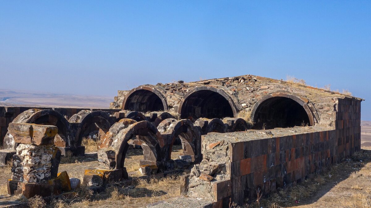
The dimensions are consistent across Armenian sources (arites.am, armenia.travel, hy.wikipedia): the surviving hall is 31 m long and 13.65 m wide, built of black tuff with mortar, floored with stone slabs. Two rows of thick pillars, eight in all, divide it into three barrel-vaulted aisles linked by arches on a north–south axis, with a single entrance for people and animals. The plan is close to Aruch: a long three-nave shed built to keep loaded animals out of the Shirak wind.
Dating varies slightly. Most Armenian references say 10th–11th century; the Shirak guidebook says 11th; a Gyumri tour operator lists 11th–12th. The 10th–11th range fits the Ani boom years (Ashot III made Ani the capital in 961). What survives is the plan, not the roof: the vaults are gone, so you walk an open rectangle of pillars and arch springers, not a roofed interior like Selim.
| Feature | Jrapi caravanserai |
|---|---|
| Date | 10th–11th century (sources range 10th–12th) |
| Size | 31 m × 13.65 m |
| Plan | 3 naves, 8 pillars in 2 rows, barrel vaults (lost) |
| Material | Black tuff, stone-slab floor |
| Original site | Nerkin Jrapi, by the Akhuryan bridge (now flooded) |
| Moved | 1970s, stone by stone, during reservoir construction |
| Elevation today | About 1,500 m |
The 1970s relocation: the dam, the move, the churches
The dam is a Cold War oddity. On 25 April 1963 the Soviet Union and Turkey agreed to dam the Akhuryan and regulate its flow jointly (Civilnet). Construction ran 1975–1980 and the reservoir went into service in 1980 (Armenian irrigation operator Jrar). Jrar gives its volume as 525 million m³ and surface as 41.8 km²; other sources quote 54 km² at full pool. The two states split the water 50/50, 262.5 million m³ each, an arrangement that has outlasted the USSR and the closed border. On the Armenian side it feeds the Armavir and Talin canals; on the Turkish side it irrigates fields around Kars and Ardahan.
The price was the valley floor. Lower Jrapi (Chirpli) and Upper Jrapi (Jeghaj) were both drowned, and a new, Soviet-planned village called Jrapi was built on higher ground for their residents: English Wikipedia and arites.am date it to 1970, Armenian Wikipedia to 1974. Shirakavan, the next village along, went under too; a 2021 Azatutyun report says about 200 families there lost 900 hectares of good land, and that the new border was surveyed by joint Soviet–Turkish teams and now runs down the middle of the water.
The caravanserai was measured, dismantled and rebuilt on the main road above the new village, “preserving the original appearance as much as possible”, in the words of the Armenian Wikipedia entry. I could not find the architect’s name or the exact year of the move in any source I trust; English Wikipedia says only “in the 1970s”. If a local gives you a date, treat it as oral history.
The two churches
Here the sources disagree. The Shirak guidebook, the most specific, says that next to the caravanserai stand “a stone by stone reconstructed, black and red tuff 1874 church, and the foundations of a single nave 11th c. church.” Hetq calls the relocated Upper Jrapi church 18th century; English Wikipedia says “two medieval church buildings”. The likeliest reading: one rebuilt village church of the 1870s in alternating black and red tuff, and one medieval footprint with little standing. Do not expect two intact medieval churches. Tour operators name the standing one as Surb Astvatsatsin.
The reservoir and the border today
From the caravanserai terrace the view is water, then Turkey. The Shirak guidebook names what you are looking at: the far village locals call “Turki Litdj” and the Tignis monastery across the line, and it rates the spot “really magical at sunset”.
The border facts, neutrally: the Armenia–Turkey land border has been closed since 1993. Russian border troops patrol the Armenian side, parts of the shore are fenced, and a 12 m boundary tower marks the line across the water (Azatutyun). Hetq’s reporting from Jrapi captures the before and after: until 1947 the river here was “only 4–5 meters wide” and shallow enough to wade, and villagers crossed as a matter of course; after the war came barbed wire and entry permits.
What this means for you: the monument is on the public road, unfenced, and described by every tour operator and guidebook as open access. Do not walk down past any fence line, do not photograph guard posts, towers or patrols, and if a border guard asks what you are doing, the answer is “the caravanserai”. Armenia’s general safety picture is excellent; border strips have their own rules everywhere.
Can you see Ani from Jrapi?
No. No source claims it, and the geography is against it: Ani sits roughly 11 km south-west, on a promontory inside the Akhuryan gorge, and the gorge walls hide it. From Jrapi you see the reservoir and the plateau on the Turkish side.
- Norshen. In December 2019 the Shirak governor announced that permission from the Russian border troops would no longer be required to enter Norshen, from where Ani is visible to the naked eye across the river (Armenpress). This has been the practical Ani viewpoint since, but confirm the current regime locally; border-strip rules change without notice.
- Haykadzor. The Shirak guidebook describes an open-access viewpoint from which Ani and the Taylar churches can be made out “only with binoculars”, with the gorge itself out of view. Haykadzor’s own 10th-century St. Grigor Lusavorich church sits inside the fenced strip and is visited on feast days with diocesan and border-guard permission (Hetq).
- Kharkov. The guidebook calls the view from the Russian base at Kharkov, west of Aniavan, the best of all, but it needs Foreign Ministry permission in advance. Not realistic for a casual trip.
Getting there
Jrapi is about 40 km south-west of Gyumri by road, in Ani municipality, at roughly 40.557 N, 43.683 E; allow an hour. The route runs south through Akhuryan town and west towards the reservoir; asphalt with potholes, and a standard car is enough. The caravanserai is on the main road above the village, about 100 m from the tarmac, with room to park. No ticket, no gate, no hours.
Public transport is not practical: village marshrutkas from Gyumri are irregular and leave you no way to continue to Norshen or Anipemza. Rent a car (see our driving and rental guide) or hire a Gyumri taxi for the day; local operators run this loop with a 10:00 departure and 20:00 return. Carry your passport: villages right on the line, such as Norshen and Haykadzor, have had permit regimes before and may again.
Pair it with
- Gyumri: your base, worth two nights in its own right. See the Gyumri guide.
- Marmashen: 10th–11th-century monastery in the Akhuryan gorge north-west of Gyumri, same Bagratuni century, far more intact.
- Yererouk basilica, Anipemza: 4th–5th-century three-nave basilica, one of the oldest standing churches in the country, 20 minutes from Jrapi, with a medieval village, cave dwellings and an early dam around it.
- Lmbatavank: 7th-century St. Stepanos above Artik, with 7th-century frescoes, on the way back towards Yerevan.
A workable day: Gyumri → Marmashen → Jrapi → Norshen → Yererouk → Gyumri, or on to Lmbatavank and Yerevan.
When to go
May to early October. Jrapi sits at about 1,500 m and Shirak winters are the hardest in Armenia; roads stay open, but a windswept ruin at minus 15 is nobody’s idea of fun. Best light is late afternoon to sunset. In dry years the shore retreats a long way and the old bridge can reportedly surface, so a September visit after a dry summer gives the odder landscape.
Practical notes
- Time needed: 30–45 minutes. Cost: free. No facilities.
- Photography: monument and reservoir are fine. Not watchtowers, fences or patrols.
- Drones: do not fly here. It is a border zone.
- Footing: uneven slabs, loose tuff, no railings on the terrace edge.
- Phone: your phone may latch onto a Turkish network near the water. Switch off data roaming.
Verdict
Jrapi is a footnote that turns out to be a good story: a Bagratuni-era inn that outlived its road, its bridge and its two villages, carried uphill in the 1970s so a joint Soviet–Turkish dam could fill the valley. The ruin is modest, the church is a rebuild, Ani is out of sight. What you get is a clear medieval floor plan, a long view over a lake that is also an international border, and a sunset the regional guidebook is right to call out. Fit it between Marmashen and Yererouk and you will be glad you stopped. Drive here expecting Selim or Ani and you will not.
Last verified: October 2026.
Frequently asked questions
Was the Jrapi caravanserai really moved stone by stone?
Yes. Armenian sources state the stones were measured, transported and rebuilt on the main road above the new Jrapi village, preserving the original appearance as far as possible. The move happened in the 1970s during construction of the Akhuryan reservoir (built 1975–1980); the exact year and the architect are not recorded in sources I could verify.
Can you see Ani from Jrapi?
No. Ani lies about 11 km south-west inside the Akhuryan gorge and is hidden by terrain. For a naked-eye view go to Norshen, where the permit requirement was lifted in 2019 according to Armenpress; Haykadzor has an open viewpoint but you need binoculars. Confirm current border-zone rules locally.
Do I need a permit to visit Jrapi caravanserai?
Not for the monument itself, which is on the public road, open and free. The reservoir shore below is a patrolled border strip with fencing; stay above it, carry your passport, and do not photograph guard posts or patrols.
Is the Akhuryan reservoir shared with Turkey?
Yes. A 1963 Soviet–Turkish agreement created it, it went into service in 1980, holds about 525 million cubic metres, and the water is split 50/50 between Armenia and Turkey. The border runs through the middle of the reservoir.
Featured image: Armenak Margarian, CC BY-SA 4.0 — via Wikimedia Commons.