Argishtikhinili is the Urartian city that King Argishti I founded on the Ararat plain in 776 BC (some chronologies say 774), roughly 50 km west of Yerevan, and the place that later became Armavir, the first capital of the Orontid kingdom of Armenia. It spreads over two mounds between the villages of Nor Armavir and Armavir: Surb Davti Blur (St David’s Hill) with the western citadel, and Armavir Blur with the eastern one. There is no ticket office, no museum on site and almost no signage; what you get is mudbrick-and-basalt wall lines, a hilltop, pottery underfoot and the full width of Mount Ararat across the valley. Since October 2024 a Polish–Armenian team has been digging here again, which makes it the most interesting unvisited Urartian site in the country.
Argishti I and the Urartian city
Argishti I ruled Urartu (the kingdom centred on Lake Van) in the first half of the 8th century BC, and he is the king who pushed Urartian power north of the Araxes. He founded Erebuni, the fortress inside modern Yerevan, in 782 BC; Argishtikhinili followed in his eleventh regnal year, which most scholars put at 776 BC (the Polish Centre of Mediterranean Archaeology uses 774). The foundation is known from his own cuneiform inscriptions, including a basalt column found near Sardarapat, and the city carries his name: “Argishti’s city”. If you have already been to Erebuni, this is its larger, less tidy sibling.
The scale is the surprise. Urartian texts describe a city served by four irrigation canals from the Araxes; the Soviet-era excavator Harutyun Martirosyan estimated the canal network at no less than 40 km, with fortifications using over 40,000 cubic metres of basalt and an economic zone of around 1,000 hectares. Archaeologists read the layout as an administrative and agricultural centre rather than a military one: it was the granary and winery of Urartu’s northern province, not a frontier fort. Inscriptions of Argishti’s son Sarduri II record further construction, including a susi temple (a small tower-like Urartian temple type) and “gates of Khaldi”, the state god.
The two mounds: what’s there
Surb Davti Blur (the western citadel, Nor Armavir)
The western hill rises about 50 m over the plain on the edge of Nor Armavir village. This is where Martirosyan’s expedition (1962–1976) concentrated, and where the Polish mission works now. The excavations exposed the citadel walls, a large columned building the AUA “Hidden Gems” catalogue describes as a palace of around 3,000 square metres, the remains of the susi temple, storerooms with rows of sunken pithoi (wine and grain jars), and a residential district of substantial houses belonging to the Urartian elite; PCMA counts nine such residences from the old digs. A seal-cutters’ workshop was identified here, and a 2020s study in the journal Aramazd notes it is the only place in Urartu where half-finished seals have turned up.
Armavir Blur (the eastern citadel, Armavir village)
The eastern mound, a steeper volcanic hill a few kilometres east, is the one that kept going after Urartu collapsed. Its summit holds a substantial temple platform and the western slope has extensive house walls, and it is this hill, not Davti Blur, that became Hellenistic Armavir. Visitors who only know the name “Armavir” from Armenian history books are usually looking for this mound.
Armavir after Urartu: Orontid capital, oracle and the Greek inscriptions
Urartu fell apart in the 6th century BC, and the Polish team’s 2024 season documented traces of a major earthquake in the Davti Blur houses, though they have not yet dated it. The place was not abandoned. When the Orontid (Yervanduni) dynasty asserted independence from the collapsing Persian empire around 331 BC, Armavir became their capital, and the Encyclopaedia Iranica treats it as the first capital of an Armenian kingdom. A 2025 architectural study by Aminia Kanetsyan (Institute of Archaeology and Ethnography, Yerevan) finds that the Hellenistic builders largely kept the Urartian citadel plan and added their own temples, sanctuaries and mosaic floors on top. The capital moved to Yervandashat on the Araxes, probably around 200 BC, and Armavir dwindled into a religious centre.
What makes Armavir unique in Armenia is the Greek inscriptions. In 1911 Galust Ter-Mkrtchian, a researcher at Etchmiadzin, reported a rock on the hill carved with Greek; in 1927 Smbat Ter-Avetisian found a second. Together they carry seven texts, dated to about 200 BC: hexameters about the poet Hesiod and his brother, a pastiche of lines from Euripides, a description of a bronze plaque of a four-horse chariot, a list of the twelve Macedonian months, and fragments of royal letters, one from a “King Mithras” to a “King Erontes” (Orontes) and another announcing a king’s death. Scholars have read them as evidence of a Greek-educated court, a temple school, or an oracle; the Armenian historian Movses Khorenatsi later wrote of sacred plane trees at Armavir whose rustling was read for omens, which fits the oracle reading rather well. The honest caveat: the inscribed rocks themselves are not something you can see on the hill. The scholarly literature treats them as lost after their early 20th-century recording, and I could not confirm any museum display of the original stones. Read the texts in translation on attalus.org before you go, and look at the hill as the setting rather than expecting to find the letters.
For the longer arc from Urartu to the Orontids and Artaxiads, see the site’s short history of Armenia.
Excavations: Soviet era to the Polish mission
| Period | Who | What happened |
|---|---|---|
| 1869 onward | Various | Cuneiform inscriptions of Argishti I and Sarduri II recorded from the area; the city’s name and date established |
| 1911, 1927 | G. Ter-Mkrtchian; S. Ter-Avetisian | Two rocks with Greek inscriptions found on Armavir hill |
| 1962–1976 | H. Martirosyan, Armenian Academy of Sciences | Main excavation of the western citadel: walls, palace, susi temple, storerooms, residences, seals; published as Argishtikhinili (1974) |
| 1970s–1990s | G. Tiratsyan | Armavir expedition focused on the Hellenistic city on Armavir Blur |
| 2019 | PCMA, University of Warsaw | Argishtikhinili project announced as PCMA’s second Armenian project (after Metsamor) |
| Oct 2024 | M. Iskra (PCMA) and H. Simonyan (IAE NAS RA) | Fieldwork resumes on Davti Blur: survey, geophysics, test trenches, rescue work |
| May–June 2025 | Same team | Second season: urn cemetery, stone idol |
| Spring 2026 | Same team, Polish NCN grant | New multi-year project begins |
After the Soviet digs the main trenches were backfilled and some walls consolidated; the finds went to the Sardarapat Ethnographic Museum, which is why that museum is the right pairing (below). Then came decades of neglect. The Polish co-director Mateusz Iskra has said in Polish press interviews that the site has been used as an illegal dump, worked over by metal-detectorists, and squeezed by the expanding village cemetery, and that 2024 was “literally the last moment” for large-scale research.
The results so far justify the urgency. In under a month in October 2024 the team found two late 7th–6th century BC residences with walls up to 1.5 m thick, a cremation cemetery with urns set in rock niches and capped with bowls (one dated by a potter’s stamp to the first half of the 7th century BC), and the earthquake evidence. The 2025 season added twelve urn burials, which the team’s bioarchaeologist called the largest and best-preserved urn-field cemetery yet found in Armenia, and a half-metre tuff slab carved with a schematic face (brows, close-set eyes, long nose, thin lips), found still leaning against a stone box inside one of the terraced houses. Those are the figures from PCMA and Science in Poland releases; full publication is pending, so treat interpretations as provisional.
Visiting today: what you’ll actually see, and how to find it
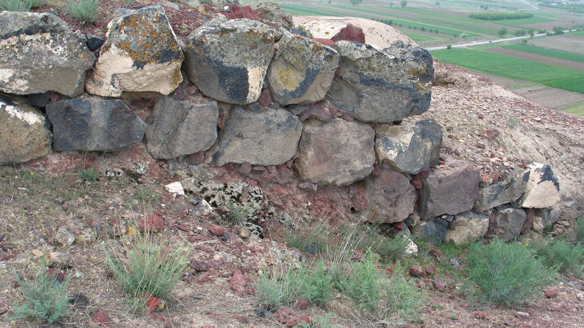
Expect an archaeological site in the raw. On Davti Blur you will see the line of the citadel wall in basalt blocks, eroded mudbrick above it, wall stubs of the excavated rooms, and a hilltop scattered with sherds. There is no fence, no entry fee and, at my last check, no interpretive panels beyond a QR-code marker; the AUA Hidden Gems project lists the coordinates as 40°09’00” N, 44°02’24” E, and that pin is more reliable than village directions. If the Polish–Armenian team is in the field (their seasons have run in May–June and October), you will see open trenches under tarpaulin. Do not walk into them, do not pick up or pocket sherds, and keep off any exposed mudbrick: it crumbles under boots. The new cemetery sits on the lower slope; be discreet around it.
Armavir Blur is less excavated and more atmospheric: climb for the temple platform and the view. The hill is the best place in the province to understand why the Orontids chose this spot, with the Araxes floodplain running south toward the Turkish border and Ararat filling the horizon. If you are collecting photo spots, this one is unusual because almost nobody shoots it.
Getting there
- From Yerevan by marshrutka. Minibuses 206 and 207 to Armavir town leave Kilikia bus station every 10–15 minutes; the fare was around 350 AMD in 2025 and the run takes about an hour for the 44–48 km. From Armavir town you still need a taxi to Nor Armavir; sources give the distance as anywhere from 7 to 15 km depending on the route, and a local taxi should cost 1,500–2,500 AMD one way. Agree on a wait or a return pickup, because there is nothing to flag down at the site.
- By taxi from Yerevan. Yandex Go or GG will quote Nor Armavir directly; budget roughly 8,000–12,000 AMD each way, more if you ask the driver to wait. The cheapest comfortable option for a half-day is a round trip with a two-hour wait.
- By car. Take the M5 west through Etchmiadzin, then follow the Armavir ring road and local roads south-west to Nor Armavir; the last stretch is paved but village-narrow. See the driving guide for the usual warnings about unlit roads after dark.
Pair it with
- Sardarapat Memorial and Ethnographic Museum (about 10 km north-east, in Araks village). This is where the Argishtikhinili finds live: pottery, seals, bronzes. See the museum first and the hill second; the site makes far more sense with the objects in your head. The 1918 battle memorial is next door.
- Metsamor (about 20 km east). A Bronze Age and Urartian settlement with a real on-site museum, and PCMA’s other Armenian project. Doing Metsamor and Argishtikhinili on the same day gives you a 2,000-year span of the Ararat plain in two stops.
- Etchmiadzin and Zvartnots are on the road back to Yerevan and need no introduction; the Urartian stop makes a more interesting day than the standard cathedral-only run.
When to go and light
April–May and late September–October are the months: the plain is green or gold, temperatures are 15–25°C, and Ararat is most often clear in the morning. In July and August the hill is shadeless and the valley hits 35°C by noon; go at 8 am or not at all. Winter visits are fine on dry days but the mudbrick is at its most fragile when wet, and fog hides Ararat for days. For photographs, the mountain is south-west of the site, so it is backlit in the afternoon; morning light puts the sun behind you on both mounds.
Practical notes
- No facilities at either mound. The nearest shops and a couple of basic eateries are in Armavir town.
- Wear closed shoes: basalt rubble, thorny scrub and, honestly, rubbish on the lower slopes.
- Village dogs are common; a stick and a calm walk are enough.
- Photography is unrestricted, but ask before photographing the team if excavations are running.
- If you read Armenian, the site is signed and searched as Արգիշտիխինիլի or Դավթի բլուր; Google Maps also knows “Argishtikhinili”.
- Allow 1.5–2 hours on site, or a full half-day combined with Sardarapat.
Last verified: October 2026. Fieldwork schedules, taxi fares and the state of signage change; the archaeological facts above are drawn from PCMA, Science in Poland, the Armenian Institute of Archaeology and Ethnography and Aramazd journal, and anything not yet formally published is marked as provisional.
Verdict
Go if you care about Urartu, early Armenian kingship or archaeology in progress, and go now, while the Polish–Armenian dig is making the site matter again. Skip it if you want a curated monument; for that, Erebuni in Yerevan is the finished product and Argishtikhinili is the unfinished one. The site rewards an hour of prior reading and a clear morning more than any other place in Armavir province, and it costs nothing beyond the taxi.
Frequently asked questions
Can you see the Greek inscriptions at Armavir?
Not on the hill. The two inscribed rocks were recorded in 1911 and 1927 and the scholarly literature treats the originals as lost; the seven texts survive in publications and translations (for example on attalus.org). Visit the mound for the setting, not the letters.
Is Argishtikhinili open to visitors and is there an entry fee?
It is an unfenced archaeological site with no ticket office, no museum and minimal signage. Entry is free. When the Polish–Armenian team is excavating (recent seasons: May–June and October), keep clear of open trenches.
How far is Argishtikhinili from Yerevan?
About 50 km by road. Marshrutkas 206/207 from Kilikia bus station reach Armavir town in about an hour; from there it is a short taxi ride to Nor Armavir village. A direct taxi from Yerevan is the simplest option for a half-day.
Which is better to visit, Davti Blur or Armavir Blur?
Davti Blur has the excavated Urartian citadel and the current dig; Armavir Blur has the Hellenistic temple platform and the better Ararat view. They are a few kilometres apart, so do both if you have a car or a waiting taxi.
Featured image: Z galstyan, CC BY-SA 3.0 — via Wikimedia Commons.