Aparan is a small, cold highland town 50–59 km north of Yerevan on the M3 to Spitak, and most people know it only as the place where the bus stops for bread. Stop properly and you get three things in one morning: the Kasagh basilica, a 4th/5th-century church that the American University of Armenia’s monument register calls one of the earliest built after Armenia adopted Christianity; the Bash-Aparan battlefield of May 1918, with Rafael Israelyan’s memorial and General Dro’s grave; and a reservoir loop walk past a church that floods every spring. Half a day covers town and memorial; a full day adds the reservoir or Yeghipatrush.
Aparan — where and what
The town sits at about 1,880 m on the upper Kasagh river, between the eastern flank of Mount Aragats and the northern slopes of Mount Ara. The 2011 census counted 6,451 people; Armenian reference sources give 5,873 permanent residents in January 2022. Winters are long: January averages minus 6 to minus 8 °C, July 17–18 °C.
The settlement was Kasagh for most of its history. Armenian sources link it to the “Kasala” Ptolemy placed in Armenia in the 2nd century, an identification I could not check against Ptolemy directly, so treat it as plausible rather than proven. From the 18th century it was Bash-Aparan; in 1935 it became Aparan, a word usually read as “palace”, after the Arsacid-era princely seat the basilica is said to have stood beside.
The Kasagh basilica (Surb Khach)
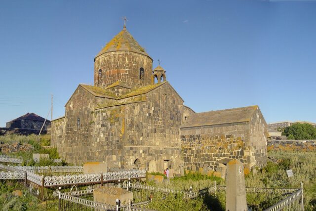
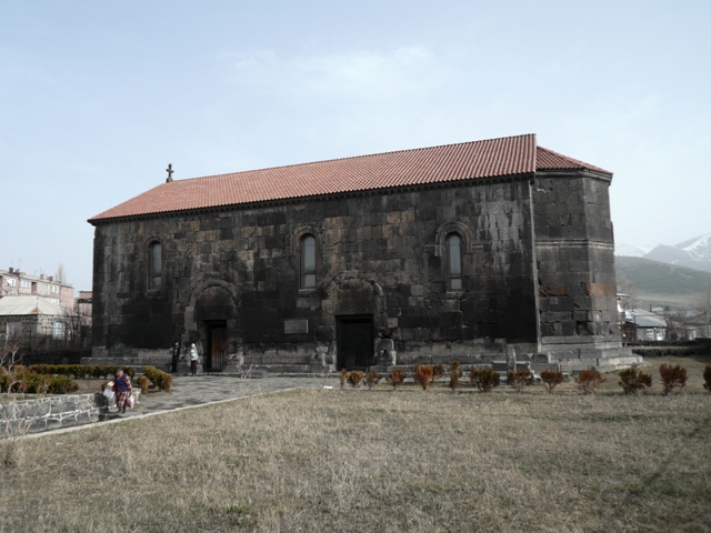
The church is in the town centre, low and long and the colour of the surrounding basalt. The AUA “Armenia Hidden Gems” register dates it to the 4th–5th century and describes a three-aisled rectangular basilica on an east–west axis: a pentagonal apse outside, horseshoe-shaped inside, and three pairs of T-shaped piers carrying horseshoe arches. There are three doors, one west and two south; a single-nave vaulted chapel was added later, and a colonnade with painted ceilings runs along the north side.
The honest caveat: English Wikipedia calls it “single-nave”. The academic register and the Armenian heritage database hushardzan.am both say three-aisled, and the piers inside settle it.
Who built it is unknown. The AUA register says no written source names the founders; the Gntuni (Gntunik) attribution comes from a Greek inscription of King Trdat found in 1908 recording the grant of the Aparan district to that house. Toros Toramanyan’s work on early basilicas underpins the dating; A. Sahinyan excavated in 1944–47. Since then: repairs and a new roof in 1877, a near-total rebuild in the 1980s (hushardzan.am gives 1980–1990), reopening for worship in 1996, and a final restoration and re-consecration in 2002. The plan is original; much of the stone is not.
The Surb Khach (“Holy Cross”) name is explained locally by a True Cross relic once kept here. I found that only in tour-company descriptions, not in the academic register, so file it under tradition. It does explain the 33 m metal Holy Cross of Aparan, consecrated in 2012, that stands above the town.
May 1918: Bash-Aparan and the memorial
In late May 1918 the Ottoman Third Army, having taken Alexandropol (Gyumri), advanced on Yerevan along three axes. One column came south from Hamamlu (today’s Spitak) down the Kasagh valley and met Armenian units in the defile at Bash-Aparan. Sources give the fighting as 21–29 or 23–29 May; the usual figures are around 12,000–13,000 men a side, though the Armenian force began as a screen of roughly 1,000 riflemen. Drastamat Kanayan — “Dro” — commanded, and on 29 May the Ottoman column withdrew north. With Sardarapat and Karakilisa (Vanadzor) the same week, it halted the advance and gave the First Republic, declared on 28 May 1918, ground to stand on. Context in our short history of Armenia.
The memorial is 1.5 km north of town on a hill left of the Spitak road — the ground the column had to cross. Armheritage.am records it as the “Revival” (Veratsnund) complex, designed by Rafael Israelyan, architect of Sardarapat, and built in 1974–1979 with his son Areg after Rafael’s death in 1973; other sources give 1978 or 1979 as completion. It is black tuff on basalt paving: a three-altar composition with memorial columns, a sword-shaped column, carved flowers and a dove, and the inscription “Eternal glory to the heroes who died for the Fatherland”. Note the Soviet framing: it was dedicated jointly to the Genocide victims, the 1918 battle and the dead of 1941–45, which is how a monument to a Dashnak general’s victory got built in the USSR at all.
Dro died in Boston in 1956 and was buried at Mount Auburn Cemetery. On 28 May 2000 his remains were reinterred on the western edge of the memorial under a basalt pyramid, at a ceremony initiated by the Armenian military and attended by his daughter. His wartime dealings with Germany in 1941–45, still argued over, are not on the plaques; the site is about 1918. Every 28 May the town’s main commemoration is held on the hill.
The reservoir walk
Aparan reservoir is the long lake east of the highway, built 1962–67 as an earthfill dam to irrigate the Ararat plain: 91 million m³ at full pool, 7.9 km² of surface. Two villages, Kasagh and Zovuni, were drowned and their people resettled near Yerevan. It has filled completely only nine times since 1969, so the shoreline varies wildly by year.
Armenianexplorer.com describes two loops through pine plantations and meadows on the eastern shore: a 4.9 km small loop and a 5.4 km big loop, about 195 m of ascent, rated moderate. Komoot users log a 6.6 km easy loop from the Surb Poghos-Petros church (210 m gain) and an 11.4 km version round more of the shore. Allow two hours for the short loops, three-plus for the long one. One Komoot warning worth repeating: do not scramble down the steep eastern shore — the soil slides.
Start from the church because the church is the point. Surb Poghos-Petros (Sts Peter and Paul) stands on the left bank at the old Zovuni site and goes partly underwater every spring. Ecokayan.com, citing specialists, puts its origins in a late 3rd/early 4th-century shrine converted to Christian use and rebuilt as a columnless domed hall in the 5th–6th century for a prince Grigor Gntuni — one of Armenia’s earliest domed halls. From roughly March to July snowmelt raises the water to its windows; armenianexplorer says three to four months a year. No conservation fix exists; Armenpress ran a 44-photo essay on it in July 2026. Go late summer to walk inside, May to see the water at the walls.
Bread, Yezidi villages and the plateau
The bread reputation is real and centred on one business: the Gntuniq bakery at 49 Marshal Baghramyan Street, on the highway in the centre, named after the same princes. Travel sites describe a row of tonir ovens, now gas-fired, where lavash is slapped on the inner wall and peeled off minutes later, plus a long counter of gata and savoury pastries. Most Yerevan–Gyumri–Vanadzor traffic stops; that is the whole business model. Why a stack of lavash keeps for weeks is in our lavash guide.
The plateau north and west is the historical core of Armenia’s Yezidi community. Around Alagyaz, about 10 km north on the M3, roughly half the villages are Yezidi — Rya Taza, Alagyaz, Sadunts, Kanch among them — with eight Yezidi villages and 260 households recorded here in 1869 and more families arriving from Kars and Ottoman territory in the early 20th century. Herding on the Aragats pastures is the main livelihood and the dairy has a good name. A temple in Rya Taza was blessed by a cleric from Lalish in December 2020. These are working villages, not attractions: buy cheese if offered, ask before photographing people.
Getting there
Minibuses to Aparan leave Yerevan’s Kilikia Central Bus Station through the day, roughly every half hour by the timetable sites, taking 1h10–1h20 for a few dollars; they set down on Marshal Baghramyan Street by the bakery. Any Spitak or Vanadzor service also passes through. The memorial is a 20-minute walk north along the highway; the reservoir trailheads are 3–5 km east, so ask the taxi rank by the bakery. By car it is under an hour from Yerevan on the M3 via Ashtarak, and the same road continues to Vanadzor and Georgia. In winter the rescue service’s bulletins regularly list the Aparan–Spitak, Aparan–Aragats and Aparan–Kuchak roads for black ice and snowstorms.
Pair it with
- Yeghipatrush — 12 km east beyond the reservoir, where the 1208 Surb Astvatsatsin church has a roofless gavit with corner watchtowers, unique in Armenian architecture. See our Yeghipatrush guide.
- Saghmosavank and Hovhannavank — the Kasagh gorge monasteries 25–30 km back towards Yerevan, same river, 800 years newer.
- Aragats from the north — the Gegharot side starts at the villages west of Aparan. It is pasture-walking country; the summit routes go from Kari Lake on the south side, covered in our Aragats guide.
When to go
June to October. May gives the 28 May commemoration and the flooded church, but snow lingers on the trails and the shore is mud. July–September is reservoir weather, around 20 °C when Yerevan is at 38. November to April the town is under snow for long stretches, and “all-season trail” claims should be read as “with gaiters and short daylight”. Basilica, memorial and bakery are open year-round.
Practical notes
| Item | Detail |
|---|---|
| Altitude | Town ~1,880 m; basilica ~1,895 m; reservoir ~1,920 m |
| From Yerevan | 50–59 km; under 1 hr by car; 1h10–1h20 by minibus from Kilikia |
| Basilica | Town centre, functioning church, free, daylight hours |
| Memorial + Dro’s grave | 1.5 km north on the Spitak road, open site, free, no facilities |
| Reservoir loops | 4.9 / 5.4 km (~195 m ascent) or 6.6 / 11.4 km; start at Surb Poghos-Petros; unsigned, carry a GPS track |
| Food | Gntuniq bakery, 49 Marshal Baghramyan St; a few highway cafes |
| Sleep | Almost nobody stays; day-trip or continue to Vanadzor/Dilijan |
Last verified: October 2026.
Verdict
Aparan is not a trip in itself; it is the best 90-minute stop on the road north, and a proper day if you add the reservoir loop and Yeghipatrush. The basilica is older than almost anything in Armenia that still has a roof, the memorial is Israelyan at his most severe, and the half-drowned church has no equivalent in the country. Fold it into a day trip from Yerevan with the Kasagh gorge monasteries, and eat the bread warm.
Frequently asked questions
How old is the Kasagh basilica in Aparan?
The AUA monument register and the Armenian heritage database date it to the 4th–5th century, one of the earliest churches built after Armenia adopted Christianity. It was heavily rebuilt in 1877, the 1980s and 2002, so the plan is original but much of the stone is modern.
What happened at Bash-Aparan in 1918?
In late May 1918 an Ottoman column advancing on Yerevan from Hamamlu (Spitak) was stopped and turned back in the Kasagh valley by Armenian forces under Drastamat Kanayan (Dro). Together with Sardarapat and Karakilisa the same week, it allowed the First Republic of Armenia, declared on 28 May 1918, to survive.
Can you see the submerged church at Aparan reservoir?
Yes. Surb Poghos-Petros on the eastern shore floods only from roughly March to July as snowmelt fills the reservoir. From late summer to autumn you can walk inside; in May the water reaches its windows.
How do I get to Aparan from Yerevan without a car?
Minibuses leave Kilikia Central Bus Station through the day and take about 1h10–1h20, dropping you on Marshal Baghramyan Street next to the bakery. Spitak and Vanadzor services also stop in Aparan.
Featured image: mcsochi, CC BY-SA 1.0 — via Wikimedia Commons.